
Backpackers.com — The merging of technology and outdoor travel has taken off in the last decade. A nice map and a compass used to be the only high-tech gadgetry needed in the wilderness. Now, though, there are high-end GPS systems, fitness trackers, stoves, tents, and the ubiquitous smartphone, which can effectively function as all of these things (well, it can't boil water, yet).
Every so often a new tech product comes into the outdoor world. Last week saw such an introduction: Meet Cairn, an app designed to track your trek and get you home safely. There are lots of outdoor apps — and we'll cover a number of them here, so stay tuned — but we wanted to give you the drop on this one, as it debuted on December 3, and proves to be an interesting combination of safety and world-building.
How to use the Cairn Backpacking App
Cairn is a simple way to send detailed information about your route in the wilderness, keeping you safe and building a collective cell coverage map in the process. See how it works below.
Start by downloading it on the App Store — it's only available for iPhone at launch, sorry Android users!
After downloading you should create a log-in (you'll need to do this to actually send a “Cairn”). Then you can create the “Cairn” by entering in the place you plan to hike, jog, or backpack.
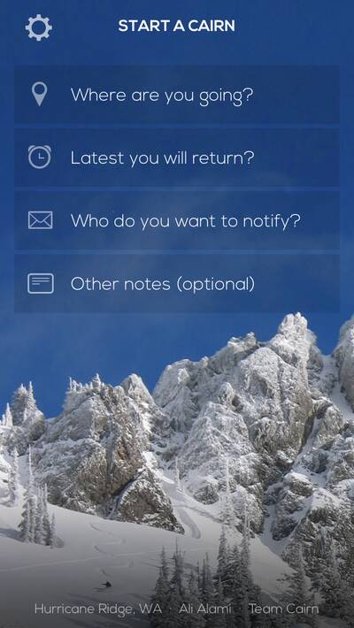
Make sure to start the process when you have cell service. Enter the general wilderness area — like Yosemite National Park — and Cairn will pull up a map and pin for the location. You then enter how long you'll be gone. Lastly, you enter the emergency contact that you want to notify about your trip.
Cairn will email the emergency contact your trip plans, so you can keep mom, wife, or husband in the loop. While you're on the hike Cairn will track your location, and if you fail to come back at the predetermined time, it will email your recorded locations to your emergency contact.
This is how it keeps you safe, and gets you home.
The route tracking feature in Cairn is not just for individual users. It also records areas with cell service to create a geolocated map of cell coverage for every user in every location. Cairn then uploads this data to a growing coverage map of the world, with the goal of having predetermined areas where cell coverage is clearly marked.
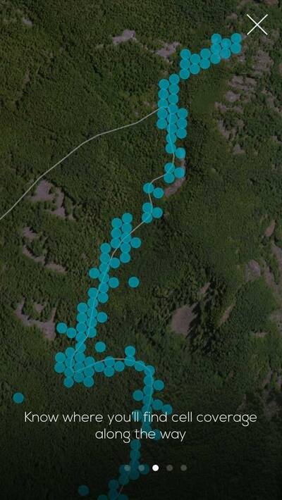
This community mapping will allow hikers and rescuers to find points in the wilderness where cell service is possible, and will aid hikers who are lost, because Cairn shows hikers the same coverage map in the app. This way they'll have access to areas with cell coverage if something goes wrong.
Because it just launched, there's not much cell-coverage data just yet. But in time there will be.
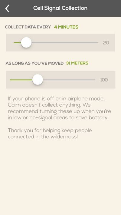
The best part is that the Cairn notification system will work even if your phone is turned off. So, if you lose or break it in the wilderness and miss your return date, it will still send your emergency contact information your last logged locations. Cairn also says the data used is minimal, and that it doesn't drain the battery too much. But, for extended day trips, the company says to “turn off your device … and carry a small battery pack.”
That's some extra weight. Might want to grab that device-recharging stove, just to make sure you're covered.
Cairn is available for free from the App Store. Enjoy, and stay safe!
All screenshots courtesy of Cairn
