
Castle Crags to Etna Summit PCT Section Hike Overview
The Pacific Crest Trail is fast becoming one of the most well-known and most-walked long-distance hiking trails in America. Its length stretches approximately 2,650 miles from the Mexican border south of Campo, California to the Canadian border near Manning Park, British Columbia. Hikers and horse riders can be found on trail all year long, but the prime thru-hiking season lies between April and October when snow levels are at their lowest.
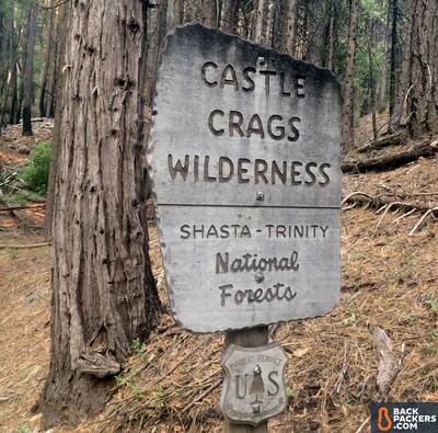
With many easy access points along its length, the Pacific Crest Trail is also widely used by day hikers and section hikers who don’t have five months to spare for a thru-hike. Looking forward to a few weeks out on the trail, I planned a northbound section hike along the Pacific Crest Trail, intending to walk from California's Castle Crags National Park all the way to Oregon's Crater Lake. I couldn’t wait to get out on this 330 mile stretch over the Marble Mountains and through the Trinity Wilderness.
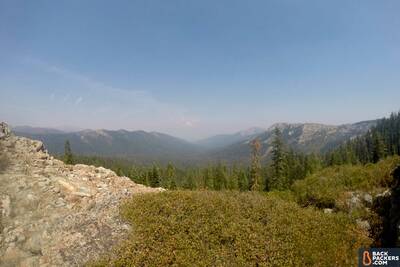
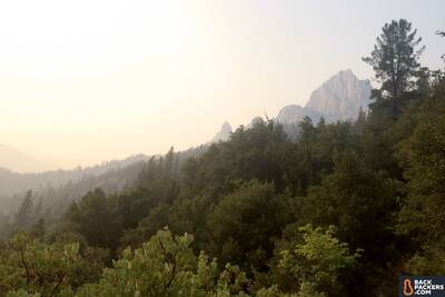
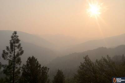
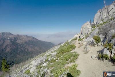
This was a smokey trip due to wildfires, but you can just see Shasta poking its head in the distance.
This is the third time in as many years that I've tried to complete this section of trail, and I'm determined to finish it. As luck would again seem to have it, my fate was altered by the wildfires that were ravaging all of western North America. Read my about my smoke-and-fire-filled journey below.
Update: I completed this trail, and the full PCT (finally), in June 2018. The trip report below is updated with the completion of that journey, and reflections on it as well.
Table of Contents
Castle Crags to Etna Summit Trip Details
| PCT Section Hike – Castle Crags to Etna Summit | Trip Details |
|---|---|
| Where | The Pacific Crest Trail through Northern California's Trinity Wilderness & Russian Wilderness. Castle Crags Wilderness to Etna Summit. |
| Length | Five days, four nights (of a planned 16 days, 15 nights) |
| Distance | 100 Miles |
| When | August 19-24, 2017 (planned August 19 to September 4, 2017), and June 2018 |
| Group | Solo |
| Environment | Alpine Forests, Granite Cliffs, Dusty Ridges, Smoky Skies |
Castle Crags to Etna Summit Trail Report
My Plan
Plans are made to be broken.
Planning for this adventure began several years ago. In 2015 I thru-hiked the entire Pacific Crest Trail with my wife, all of it except for the section between the Trinity Wilderness and Russian Wilderness in Northern California. After hiking 1,500 miles on the Pacific Crest Trail, a debilitating case of tendonitis had flared in my right foot, which took me off the trail for a couple weeks. Having a timeline we needed to stick to, my wife continued the journey solo during my recovery time, walking day after day alone until I was able to return to her and the trail at Crater Lake National Park.
We finished our Pacific Crest Trail journey six weeks later at the Canadian border and I was officially a thru hiker, a man who had walked from Mexico to Canada…except for this one piece of trail. It was a chip on my shoulder, an asterisk to my adventure.
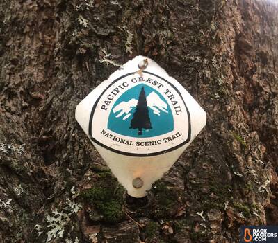
The Pacific Crest Trail marker on a tee. You're in the right place.
So I planned to complete it the next year, 2016, this time with my father. We made it about 15 miles southbound from Crater Lake before calling the trip a wash. There was still too much snow in June and we weren't confident enough in our abilities to take on the challenge.
So I planned to complete it the next year, 2017, this time with my sister. Sense a theme? I don't often hike alone. We set our start date near the end of August to avoid the snow, but for personal reasons my sister had to abandon the adventure just weeks before it was set to begin.
I was determined to continue on, but a few logistics had to be altered since this was now a one-person journey. This was easier, in a way, since I knew what hiking pace I was capable of maintaining. Using Craig’s PCT Planner, I scheduled my expected resupply dates and their locations. Here’s a full overview of my plan.
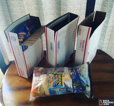
Resupply boxes. Hiker food is the best food.
With an average of 21 miles per day I would only need to make two resupply stops, and though I could have decided to take some rest days (aka “zero” days, as in zero miles walked), I figured I could make the whole trip in one go and rest when I was done.
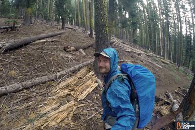
I wasn't looking forward to being alone for nearly a month of walking, but the timing seemed right and I had a mission to accomplish. Flex Capacitor fully packed and resupply boxes mailed, I was all set to jump back on the Pacific Crest Trail and see what beautiful scenery this section had to offer.
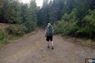
Setting off on my solo section hike of the Pacific Crest Trail. The Sierra Designs Flex Capacitor fully loaded.
I did not need a permit for this trip, though most long-distance PCT excursions will require one. If you’re hiking over 500 miles of the trail in one trip you’ll need a PCT Long-distance Permit, and other agencies (such as National Parks) have their own permits and regulations for the land they manage that you’ll be walking over.
The Trip!
The trip started with uncertainty. All the trails in Crater Lake National Park had been closed due to fire the week before, but I found a workaround that would allow me to finish 99% of my intended hike. Then, the day I was setting out to start, another section of trail was closed by fire in the Marble Mountains. Again, I found a workaround (which the Pacific Crest Trail Association is always quick to help with on their PCT trail closure webpage), but it seemed as if the wildfires were growing out of control.
Starting at the start of this PCT section hike.
Smoke and More Smoke
I triple-checked to make sure that where I would be starting out was safe to hike. Other hikers had posted online that the trail was good, that all I had to do was climb up above the layer of smoke.
When I say smoke, I mean it.
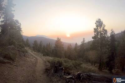
I stepped onto the Pacific Crest Trail knowing that if I had to turn around I would do so without hesitation. Smoke filled the skies all around me, so much so that I couldn't catch even a glimpse of the prominent Mt. Shasta which dominates the area's landscape on a typical day.
My trek began with a 5,000 foot elevation gain as I climbed my way up into Castle Crags State Park. The stellar mountaintop rock formations were hidden from my view in the smoky haze, but the forest through which I hiked must have filtered the air somehow because I was able to breathe just fine. Thank you trees!
The peaks of Castle Crags covered in smoke.
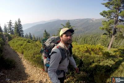
The La Sportiva Wildcats gripped the trail's incline well as it transitioned from dry dust to granite boulders. After 20 miles of nothing but uphill I would have thought that my feet were going to be covered in blisters, but they weren't!
Once I had made it to the top of the ridge I started having trouble. I was above the worst of the smoke, sure, though the late August heat was another factor, as was the altitude. My home at the time was on the Oregon Coast (I’m in Eugene now) so I had become accustomed to a cool breeze at an easy-breathing 15 feet above sea level. In one day, though, I had hiked my way up to where the air was thin and the sun shined brighter than the inside of a tanning bed.
Knocking down the miles.
I would like to say that I took my time by waiting out the heat of the day in the shade while sipping some cool creek water from my Smartwater Bottle (that would have been the smart thing to do), but the CLIF Bar-fueled hiking engine inside of me fired up and my legs crushed more miles despite the torrid conditions. I made 30 miles on the second day and likely would have done so again the next day if a thunderstorm hadn’t stopped me in my tracks.
Thunder, Lightning, Oh My!
The heavens started rumbling early in the morning of the third day before there was even a cloud in the sky. I knew that these Northern Californian mountains were infamous for their surprise thunderstorms, but I was still shocked to see the massive thunderhead that crept up on me later in the afternoon. It came out of nowhere!
The clouds moved in closer as the minutes passed and all around the air shook with electric intensity. There was a moment when the wind stopped, when the forest became quiet and still, and then the rain finally fell.
In the wilderness, when it rains it pours.
I threw on my backpack rain cover and Frogg Toggs rain jacket, then ran under a tree to wait out the worst of the storm. Ahead of me was a bare ridge, a place I did not want to be while lightning exploded above me like a barrage of fireworks.
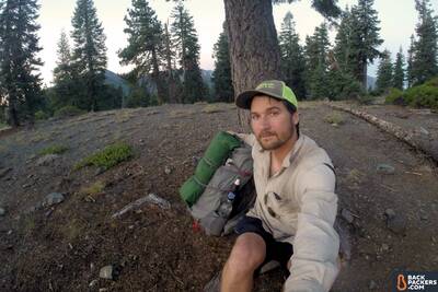
A painful headache kicked in following the atmospheric pressure change of the storm, and so when the weather lightened I took the opportunity to pitch the Tarptent Double Rainbow to rest. It was early to set up for the night, but I was exhausted. I spent some hours reading stories on my phone before drifting off to dreamland.
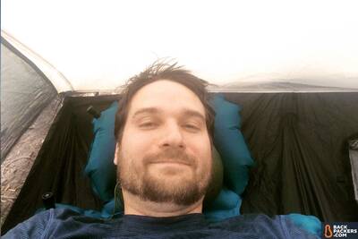
Dreamland is but a moment away.
Smoke, Once Again!
That night, at some ungodly hour between midnight and sunrise, I woke up in a panic. My tent was full of smoke, enough so that I was choking with every breath. My first thought was that one of the nearby fires had flared up while I was sleeping, or maybe the thunderstorm had started a new blaze right near my campsite.
I got out of my tent in the pitch blackness of the night. It was difficult to see, not only because of the darkness, but also because I had fallen asleep with my contacts in, causing them to be dry and blur my vision. After a lot of eyeball rubbing I walked to a bare spot on the hill with a 360 degree view of the surrounding area. The smoke was still intense, but I saw no other signs of fire in the vicinity.
Obviously not that night, but here's an idea of the smoke on the trail.
Should I stay or should I get up and hike in the darkness of the night? What if I were to walk right into the fire? Fear was rampaging through my thoughts. The decision I was about to make could literally be life or death.
Maybe it was because I couldn’t spot any nearby sources of smoke or fire, or maybe it was because my desire to get back to sleep was stronger than my fear of a fiery death (probably the latter), but I decided to stay where I was until daylight. I knew that my immediate area was fire free: I wasn’t so sure about the trail ahead. The winds soon shifted, abating the intensity of the cough-inducing fumes, and by morning all was well again.
Later that day I found a spot of cellular service on top of a mountain and learned that the trail closures had grown to the point where there was no longer an alternate route around them. I would have to skip the majority of the Marble Mountains by catching a ride from the town of Etna to Seiad Valley. It was unfortunate that I would have to miss a part of the trail.
Plans are made to be broken, though.
I had made it to the last stretch before Etna, hiking up a rocky part of the trail when I saw four deer about 200 feet ahead coming down the path toward me. This was along a granite cliff with nothing but boulders above and below. I stopped and watched the deer as they walked, then they suddenly darted downhill at a breakneck pace. It took me a moment to process that a cougar was chasing them down the ravine.
You can't see the cougar or deer, but they're down that slope.
I swear to you that I have never hiked faster in my life then I did after witnessing that 200 pound cat hunt down its prey. I hustled past where I saw the cougar race after the deer (who knew if there were more hiding behind the rocks above? Ahh!) and did not stop for the next 10 miles until I had made it to the road to Etna.
Update: Back on Trail June 2018
What a difference a year can make.
Once again I went back to the Pacific Crest Trail in the summer of 2018 to finish what I had started. The past winter had dropped an extremely low amount of snow in the Cascades, and I had to plan around that. Low snow meant the trail would be clear for easy walking, but it also heightened the risk of early summer fires.
I didn't need a repeat of last year, so I started earlier this time — in June. The plan was to begin at Crater Lake and walk southbound back to Etna Summit to finally, once and for all, finish this damn trail — this beautiful-difficult-spectacular-exhausting-amazing damn trail.
I was fortunate to be joined by my wife and a friend for the first 100 miles. Together we left Crater Lake's Mazama Village and enjoyed the five days we had together, trekking through burnt forests and taking in spectacular views of Oregon's Mt. McLoughlin to the west and the expansive Upper Klamath Lake to the east.
All in high spirits, we skipped downhill like frolicking children over the last 10 miles to Callahan's Lodge outside of Ashland, where we shared a wonderful meal at the thru-hiker frequented pit stop. It was here my companions jumped into a car and drove home while I hoofed it back to trail, resupplied and eager to reach the Oregon/California border.
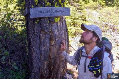
Crossing the border.
Trail Connections
I made it another 10 miles that night and camped at Grouse Gap Shelter where I spent a merry evening with a handful of 2018 thru-hikers — we swapped stories and learned who each other were. One couple in their mid-sixties had met and married while backpacking over 30 years prior, and they haven't stopped since. While we were chatting, another hiker showed up who had met that same couple years ago in the mountains of Patagonia — they hadn't seen each other since this chance meeting. He was the person who suggested they try the Pacific Crest Trail and was the reason they were thru-hiking.
This is my favorite part of long-distance hiking– you get to meet some wonderful people out there.
Onward I continued toward the itty-bitty town of Seiad Valley, which was full of hikers. Breakfast at the cafe was simply scrumptious. I spent a couple of hours savoring the food and scrolling through the 2015 trail journal to see the notes left by my old trail friends. I even found my wife's entry!
From town it was a long, long 17 mile uphill slog through poison oak and severely overgrown brush. By the end of this day I just couldn't wait to crawl into my sleeping bag, but fate had one more adrenaline rush prepared for me, a twilight moment when I made eye contact with a cougar near Paradise Lake. Yes, another cougar! Gah!
I survived. The cat ran away, as did the bear I saw the next morning. My final days strolling along the ridges of the Marble Mountains were absolutely beautiful, though the smoke had returned and was once again tinting the sky with a tallow yellow hue.
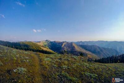
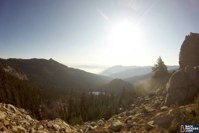
A beautiful trail indeed. Marble Mountain Wilderness.
Approaching Etna Summit, I crossed paths with a trail crew hiking in to further clean the stretch of trailside forest which had burnt down the previous year, the same stretch I was so close to. I reached the summit, then waited for 30 minutes before I caught a ride into Etna by a man who was on his way to pick up his family from the town of Hornbrook, where their home had just burned down in the burgeoning Klamathon wildfire. A nearby section of the Pacific Crest Trail closed the very next day.
Reflections
Unfortunately, Etna is where my hike ended. Once in town I learned that the wildfires had exponentially increased, and now the trail north of Seiad Valley was closed as well. With most of the remaining Pacific Crest Trail toward Crater Lake under fire, I decided to end it now before it got any worse and make another attempt at this section in the future. Yes, again.
I met some thru hikers in town who were despondent, to say the least. Earlier in the summer they had to work around the heaviest Sierra Nevada snowfall in recorded history, and now they were trying their best to plan their hike around the numerous fire-caused trail closures.
Plans change, people. Plans change.
This section of the PCT is beautiful, even through a smoky haze, and I can't wait to get back on it to finish what I started. It's crazy how the conditions on any one section of trail can drastically change — from dry and smoky to wet and cold to summer snow, but that's all part of the adventure. You never know what you're going to be faced with, and it's going to be a different experience for every person.
A reflective moment on the trail.
This was my first time backpacking solo for such a long stint. It was frightening, challenging, and exhilarating. The fear was much more intense. Not only was I walking in a party of one, but because the fires were so bad there was hardly another soul to be found out on the trail. There was no one to share my fears with, no one to rely on if fire, thunder, or cougars got the best of me.
I would have enjoyed it more with a partner, and felt safer, but I'm glad to have a journey to call my own, to tell stories about. It was a test of self-reliance, a solitary exploit where my experiences, abilities, and courage were pushed to their limits. I’ll backpack solo again, though maybe not when wildfires threaten to bake me like a hiker cake.
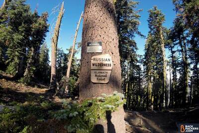
A sign in the Russian Wilderness.
I'd encourage you to give this section of trail a try, or any part of the Pacific Crest Trail. I’ll be back on it next summer. It's an easy trail to follow, and it's gorgeous every step of the way, but plan properly, be safe, and know that plans are made to be broken.
Updated Reflections
I enjoyed a celebratory beer in Etna and was happy to have finally “finished” the Pacific Crest Trail. It was a bittersweet accomplishment, though, and one I'm still processing now. I think I'm going to take a break from that specific trail, maybe for a few years, but I don't think I'll ever believe that I am done with it. That trail is my home. Everywhere on that trail is my home.
Read more about Arthur's Pacific Crest Trail thru-hike and trail stories.
Backpackers.com Affiliate Policy: This Trail Report contains affiliate links, which help fund our website. When you click on the links to purchase the gear we get a commission, and this goes a long way to creating guides, gear reviews, and other excellent content.

Hey Arthur. Thank you for all of the helpful information! I am planning my first hike out on the PCT. I am an avid runner and have done several marathons, but would like something more in nature.
Your story is great – is it possible to connect with you over phone or email to ask you a few questions? Any help would be appreciated.
Thanks,
Chris
Hi Chris. If you’re in marathon shape you will be crushing many trail miles soon enough! I’ll send you an email.
Hi Arthur, thank you for your stories. My husband and I would like to hike from Castle Crags to Seiad valley this summer. Would you mind send us an email so we can ask more questions? Thank you so much!